Photo credit: Theavidoutdoorsman.com
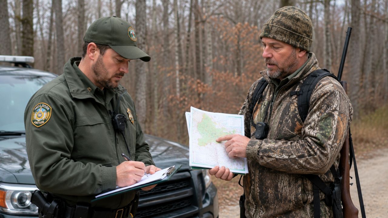
It was the kind of stop that usually lasts a minute: a truck eased onto a two-track at first light, a hunter climbed out to stretch his legs, and a game warden rolled up slow and steady behind him. License check. Tag check. Quick glance at the firearm case in the back seat. Then the warden’s eyes went right to the hunter’s chest and shoulders.
No blaze orange.
The hunter didn’t argue about safety. He didn’t get loud. He just pointed at the folded paper map on his dash—one of those state hunting atlas maps with color blocks and boundary lines—and said the parcel he was on didn’t require orange for the season he was hunting. That’s where a routine check turned into a longer roadside conversation with a citation book already half-open.
A simple gear check turned into a map-and-boundary problem
The warden’s position was straightforward: during the active firearm season, hunters need to wear blaze orange. That’s a rule most of us know so well we don’t even think about it. In a lot of states, it’s one of the most enforced regulations because it’s tied directly to not getting shot.
The hunter’s position was also straightforward: the state’s own map showed the property was part of a special-use area where the orange requirement was different. Some parcels—depending on ownership, management plan, species, or the weapon/season framework—fall under separate rules. That can mean archery-only zones tucked inside a wider firearm season, limited-entry areas, or small tracts managed under different safety regulations.
From the warden’s perspective, the lack of orange is an easy visual violation. From the hunter’s perspective, he’d done the homework and was standing on the right side of a line most folks never see.
Why “no orange” isn’t always as clear as people think
Most hunters hear “orange required” and assume it’s universal. Usually it is. But there are legitimate exceptions in many rulebooks—especially where the state has a patchwork of public parcels, walk-in access programs, and cooperatively managed lands with their own printed regs.
Some states carve out “special regulation units” where weapon restrictions differ from surrounding ground. Others separate requirements by species and season dates, not just by the calendar month. The confusing part is that the line on the map doesn’t always match what you feel on the ground. A hedgerow, a creek, a fence that’s down, or a grown-over old road can make you think you’re in one block when you’re actually in another.
And then there’s the biggest curveball: some rules aren’t tied to who owns the land, but to what hunt is happening nearby. If there’s a general firearm season open for deer, but you’re hunting predators under a different framework, orange may or may not be required depending on how the regulation is written. It’s one sentence in a booklet, and it matters.
The moment the warden wrote the ticket
According to how these situations typically play out, the warden likely did what wardens are trained to do: apply the regulation as they understand it in real time. The citation came out, the hunter got the standard explanation, and that’s when the hunter brought the map into the conversation.
Not a screenshot. Not a buddy’s text. An official-looking state atlas with the parcel shaded and labeled, plus the hunter’s finger on the boundary line.
That’s when things get tense in a quiet way. Not “raised voices” tense. More like “now we need to be sure” tense. Because if the hunter is right, the ticket is wrong. If the hunter is wrong, the ticket stands and he’s just learned an expensive lesson.
In the field, a warden has to decide whether to void the write-up on the spot, issue a warning, or let the court/administrative process sort it out. Some will stop and verify with dispatch or a supervisor. Others will tell you to take it up later, especially if their mapping system or training says orange is required there.
How a small map detail can decide who’s right
The devil in these cases is usually one of three things: the exact parcel boundary, the exact season category, or the exact definition of “firearm season.” A hunter can be standing on public land and still be under a special set of rules because it’s managed differently than the section next to it.
Those state maps are helpful, but they’re not always the final authority. Some are printed annually but rely on older boundary data. Some show “access areas” without spelling out all the special regulations that apply once you’re inside. And sometimes the map is right but the hunter is actually parked or walking on a sliver of adjacent land—like a right-of-way, a corner of private, or a separate public tract with different rules.
The cleanest version of this is when the map and the regulation booklet match up perfectly and the hunter can point to the exact paragraph that says orange isn’t required on that parcel for that method of take. The messiest version is when the map is correct but the hunter can’t prove he was inside that boundary at the moment of contact.
If you want to avoid this altogether, this is where a GPS-enabled mapping app with public/private layers and offline boundaries earns its keep. Screenshots with the date/time and a dropped pin are not a guarantee, but they’re a lot better than “I think I’m on the right side of that creek.”
What other hunters focused on: safety, enforcement, and “just wear the orange”
Anytime a blaze orange dispute comes up, the crowd splits fast. One group says, “Wear it anyway.” They’re not wrong on the safety side. Even if the law doesn’t require it on a specific parcel, orange prevents mistakes—especially when other hunters may not know the same special rules you’re following.
The other group focuses on the principle: if the state publishes a map showing an exception, and you follow it, you shouldn’t be penalized because an officer is working off different information. Hunters are expected to know the regs, but the regs have to be clear and consistent, too.
A third group usually chimes in with practical advice: don’t argue on the roadside. Take the ticket. Document what you can. Handle it the right way afterward. That’s not surrender—it’s just understanding that a debate in the ditch rarely ends in your favor, even when you’re right.
The best way to handle it if it happens to you
If you ever find yourself in that same spot—ticket book out, you’re convinced you’re legal—keep it simple and keep it calm. Show your documentation: the current-year regulation booklet, the map, and if you have it, your GPS boundary layer. If you can pull up the specific paragraph that creates the exception, do it.
But don’t turn it into a standoff. A warden is doing a job, and the fastest way to make a solvable paperwork issue feel personal is to get snippy. If the citation is issued anyway, your next move is administrative: contest it, bring printed regs, bring the map, bring proof of location, and be ready to explain the season framework you were operating under.
And here’s the part nobody loves to hear: even if you’re technically exempt, wearing orange during busy seasons is still smart. A lightweight vest over your jacket or an orange cap in your pack doesn’t ruin a hunt. It just makes you harder to mistake for a deer when somebody else is hunting the next ridge over with a different understanding of what’s open.
These land-parcel exceptions can be real, and hunters shouldn’t get tagged for following the state’s own guidance. But the best outcome is never needing to prove it in the first place—by knowing your boundaries cold, keeping the regs on hand, and making visibility a habit when the woods are crowded.
Like The Avid Outdoorsman’s content? Be sure to follow us.
Here’s more from us: